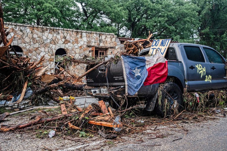
The National Weather Service (NWS) in Texas issued warnings about heavy rain and potential flash flooding, but the severity of the storm exceeded forecasts and the warnings were not fully effective due to a combination of factors including the overnight timing, the speed of the rising water, and potential limitations in emergency alert systems. While the NWS did issue warnings, the extreme rainfall and rapid flooding overwhelmed some areas, leading to tragic consequences.
Here’s a more detailed breakdown:
- Overnight Timing:
The heaviest rainfall and floodwaters rose during the overnight hours, a time when people are less likely to be paying attention to weather alerts or be able to react to them.
- Rapid Flooding:
The rainfall was exceptionally intense and fast-moving, leading to flash floods that rose quickly and unexpectedly.
- Potential for Improved Forecasting:
Some experts suggest that improvements in quantitative precipitation forecasting could help forecasters better identify the potential for extreme events.
- Emergency Alert Systems:
There are questions about the effectiveness of emergency alert systems, including whether they were effectively reaching all residents and whether the alerts were clear enough about the potential danger.
- Staffing and Budget Cuts:
There has been debate about the impact of potential staffing and budget cuts at the NWS on their ability to monitor and predict weather events. However, some experts say that the cuts did not play a significant role in this particular event.
It’s important to note that the NWS does not control the weather itself. It provides forecasts and warnings to help people prepare and stay safe, but the effectiveness of those warnings depends on various factors, including how well they are communicated and how people respond to them.

WHAT WENT WRONG?
Regarding the Texas flood event and the National Weather Service (NWS), several factors have been discussed related to the effectiveness of warnings and forecasts:
1. Forecasting Challenges:
- Extreme Rainfall: Experts noted that the forecasting models didn’t adequately predict the severity of the rainfall that caused the flooding. The amount of rain that fell significantly exceeded what was forecast.
- Difficulty in Localized Forecasting: Predicting the precise location and intensity of such localized and rapid events, like the significant flash floods that occurred, is inherently challenging.
- Computer Model Limitations: Current weather models have limitations in resolving very small-scale weather features like individual thunderstorms, requiring estimations at times.
2. Warning System and Communication:
- Lack of an Adequate Warning System: Some areas, like Kerrville where significant damage occurred, didn’t have a specific alert system in place for residents to receive warnings.
- “Last Mile” Communication Breakdown: While the NWS issued warnings, there were issues with how these alerts reached people, particularly during the overnight hours when many were asleep. Some crucial warnings came in the pre-dawn hours, making it difficult for people to react.
- Missing Key Personnel: The absence of key personnel, like a Warning Coordination Meteorologist, at NWS offices in the affected regions raised concerns about communication and coordination with local authorities. This role is vital for translating forecasts into actionable plans.
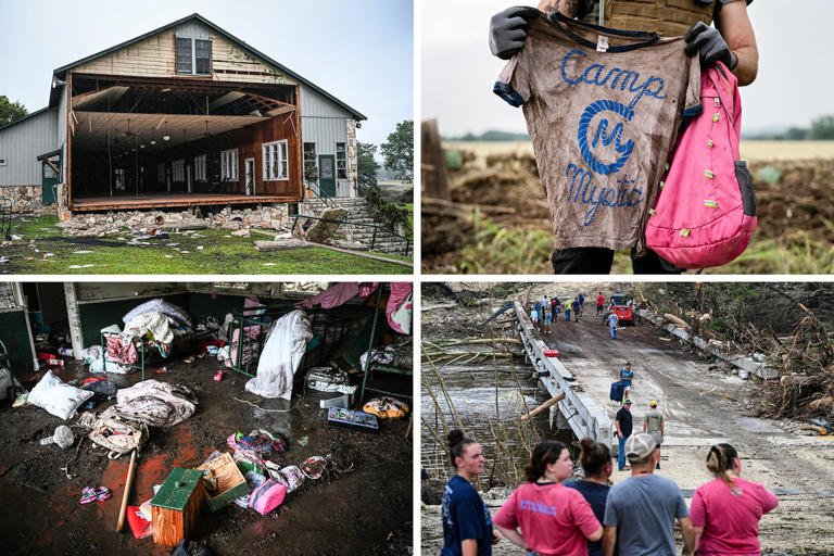
- Local Authorities’ Response: Some local officials criticized the NWS forecasts for underestimating the rainfall and did not feel adequately prepared for the severity of the flooding. There were also questions about decision-making regarding evacuations and how camps handled their disaster protocols.
3. Impact of Budget Cuts and Staffing Shortages:
- Debate over Staffing: There is an ongoing debate about the extent to which staff reductions and job cuts at the NWS may have impacted the ability to issue timely and accurate forecasts, or to adequately coordinate with local officials.
- Concerns about Future Impacts: Former officials and experts express concerns that funding cuts could hinder future forecasting capabilities, particularly for severe weather events.
In summary, while the National Weather Service issued warnings about heavy rain and the potential for flash flooding, several factors contributed to the tragic outcome in the Texas floods. These include limitations in forecasting extreme rainfall events, communication breakdowns in the “last mile” to reach residents, and concerns about the impact of staffing shortages and budget cuts on the NWS’s operational capacity.